Look again, because there is just such a trail, the North Country National Scenic Trail (NCT). It’s 4,400 miles long, the longest hiking trail in the United States, and stretches from New York to North Dakota, winding its way through seven states. What? You never heard of it? Despite much good promotional effort the NCT seems to remain a well-kept secret.
Experience the Backcountry
As “my” group of four hikers was traveling west on the Kekekabic portion of the trail (in the Boundary Waters Canoe Area Wilderness), I stepped into a large clearing paved with boulders. Entering across the rocky way was another hiker.
“Hellooooo, Joan,” he called. “Hellooo, Matt,” I hollered back, and we stumbled toward each other across the angled stepping stones in a swaying slow motion parody of lovers running together through a field of waving wheat. Matt and his cadre of 11 hikers were headed east.
The encounter was remarkable, because the North Country
Trail is so vast, with low traffic, that one seldom finds other hikers/walkers,
except perhaps near population centers. Here we were, meeting on one of the
least-hiked sections. Although not contrived, our meeting was expected, since I
had known his plans. After 18 years of meeting almost no one on the NCT, this
was a big deal. We perched on more rocks, sharing our lunches and trail stories
before moving on toward our respective goals.
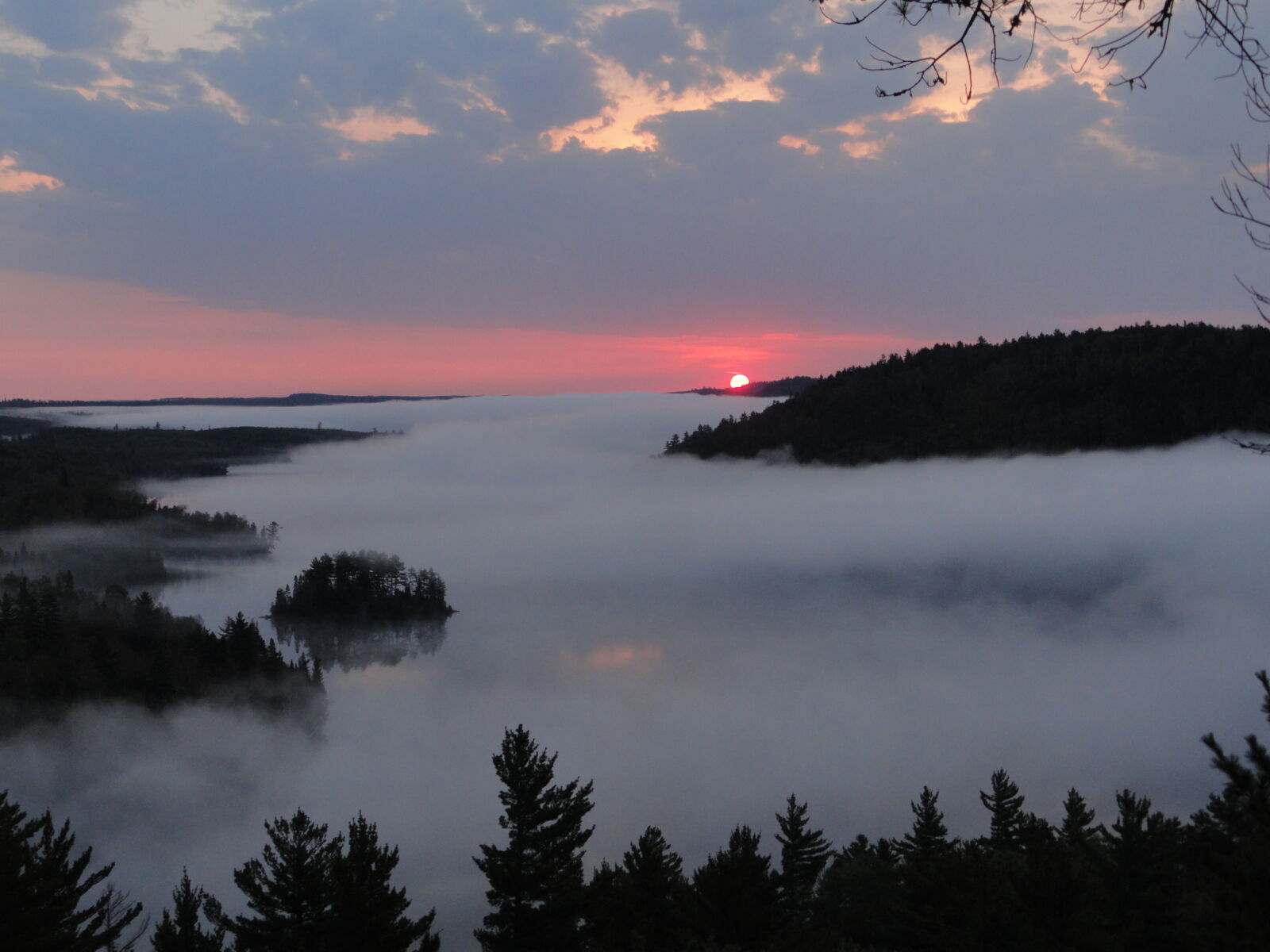
Photo by Doug Boulee
Border Route sunrise.
For the most part, hiking the NCT is not yet a social experience, but more hikers take on the challenges of this trail each year. Most people are amazed to discover that it is possible to find long stretches of trail, away from civilization, on a trail traversing the North and East.
Don’t Underestimate the NCT
You might think that a trail with no major mountain ranges and so near to cities and towns is bound to be easy. Many long distance hikers have thus underestimated the challenges of the North Country Trail. The sheer length of the trail is a challenge in its own right. To do a thru-hike requires nine or 10 months, even for a fast hiker. But the NCT is not a trail that should be hiked quickly.
Yes, there are portions of this trail that are level multi-use paths. The NCT takes in small towns, city parks and still includes a large number of miles of roadwalk. But, many people think this implies that the entire trail is a walk in the park. Not so! The challenges of hiking up and down the hills of New York’s Southern Tier (affectionately called “The Western Wall” of New York) or traversing the volcanic upheavals along Minnesota’s north shore of Lake Superior should not be taken lightly. The hills of Pennsylvania are substantial, Michigan has the Trap Hills, and the open spaces of North Dakota require a different kind of stamina to complete. Ohio is not all the flats of the Great Black Swamp, and Wisconsin sports some geologic surprises as well.
Herein lies the great strength of the North Country Trail:
its diversity. This is a trail to sample and savor. Along its length can be
found over 100 waterfalls, remnants of virgin forest, the amazing Pictured
Rocks of Michigan, rare plants and geologic oddities. Although it’s a National
Scenic Trail, there is plenty of history to be found: spider webs of 19th
century canal systems, historic logging and mining sites, Great Lakes
shipwrecks and lighthouses, ancient cemeteries, Ohio’s Serpent Mound, and more,
all calling to lovers of times past. For those with an engineer’s mind, there
are dams, canal locks (some abandoned—allowing exploration, some restored for
education), and an abundance of bridges from the Mackinac Bridge spanning the
straits between Lakes Michigan and Huron to rustic stringers of peeled logs.
The trail uses numerous covered bridges and the only remaining Fink Truss
Bridge in the world. Transportation themes abound. The canal systems have been
mentioned; long forgotten narrow-gauge railroads with nicknames like the “Bent,
Zig-zag and Crooked” or “Poverty, Agony, Distress and Want” are yet preserved
in berms that wind through second-growth woodlands. Rivers, the 1811 National
Road, and portages used by the Voyageurs, all remind the hiker that others have
passed this way before.
Much of the trail affords what might be officially called a backcountry experience—places where a hiker can disappear into the woods for two or more days and be free of many of the sounds and sights of the populated world.
Naturalists will be delighted with the variety of ecosystems along the NCT. Botany is one of my personal obsessions, and I never tire of discovering new plants. Eastern hardwood forests dominate the trail corridor, but one can find marshes and bogs, Great Lakes dunes, islands of alpine ecosystems, oak savannahs, and the great prairies of North Dakota. From the large Eastern prairie fringed orchid to tiny Sullivantia, there is no shortage of interesting plants, rare and common. Hikers of the northern stretches have reported seeing moose, and even a cougar or two. Black bear are sighted more often, but quickly run away from hikers. Chipmunks and squirrels are more likely to compete for one’s trail lunch, and mink, otter, and even a marten may occasionally be seen. Deer, of course, are ubiquitous, and beaver delight in creating ponds which necessitate creative trail maintenance. Butterflies range from the stunning but common orange monarchs, to the endangered Karner blue.
Beginnings
The trail was conceived in the mid-1960s, and the Forest Service was a key player in that birth. The idea was simple: to connect and showcase scenic and natural wonders across the northern tier of states. It took until 1980 for the concept to be developed enough for Congress to authorize the NCT as a National Scenic Trail, a sister to the already designated, and better known, Appalachian, Pacific Crest and Continental Divide Trails.
Early on, the National Forests embraced the idea of building this trail, and the first sections to be built off-road were in the Allegheny National Forest of Pennsylvania; the Huron-Manistee, Hiawatha and Ottawa National Forests of Michigan; Chequamegon National Forest of Wisconsin; Chippewa National Forest of Minnesota; and the Sheyenne National Grassland of North Dakota. That’s an impressive list of forest connections, but it’s only just over half of the actual total. Since that time the Finger Lakes National Forest of New York and Wayne National Forest of Ohio have added NCT miles. The Superior National Forest in Minnesota’s Arrowhead region is poised to be added as the 10th forest on the list. The NCT route has been rerouted to trace the Arrowhead, but official Congressional approval is still pending.
In 1981 the North Country Trail Association (NCTA) was founded, as a nonprofit, to work with the National Park Service (NPS) to build, maintain and promote the trail. The NCTA, NPS, and U.S. Forest Service (as the NCT’s largest land manager), work together under a memorandum of understanding and are usually referred to as the triad of groups with the greatest impact on the North Country Trail. Thousands of volunteers are working through the NCTA and affiliate organizations to complete the trail offroad. It’s a huge task!
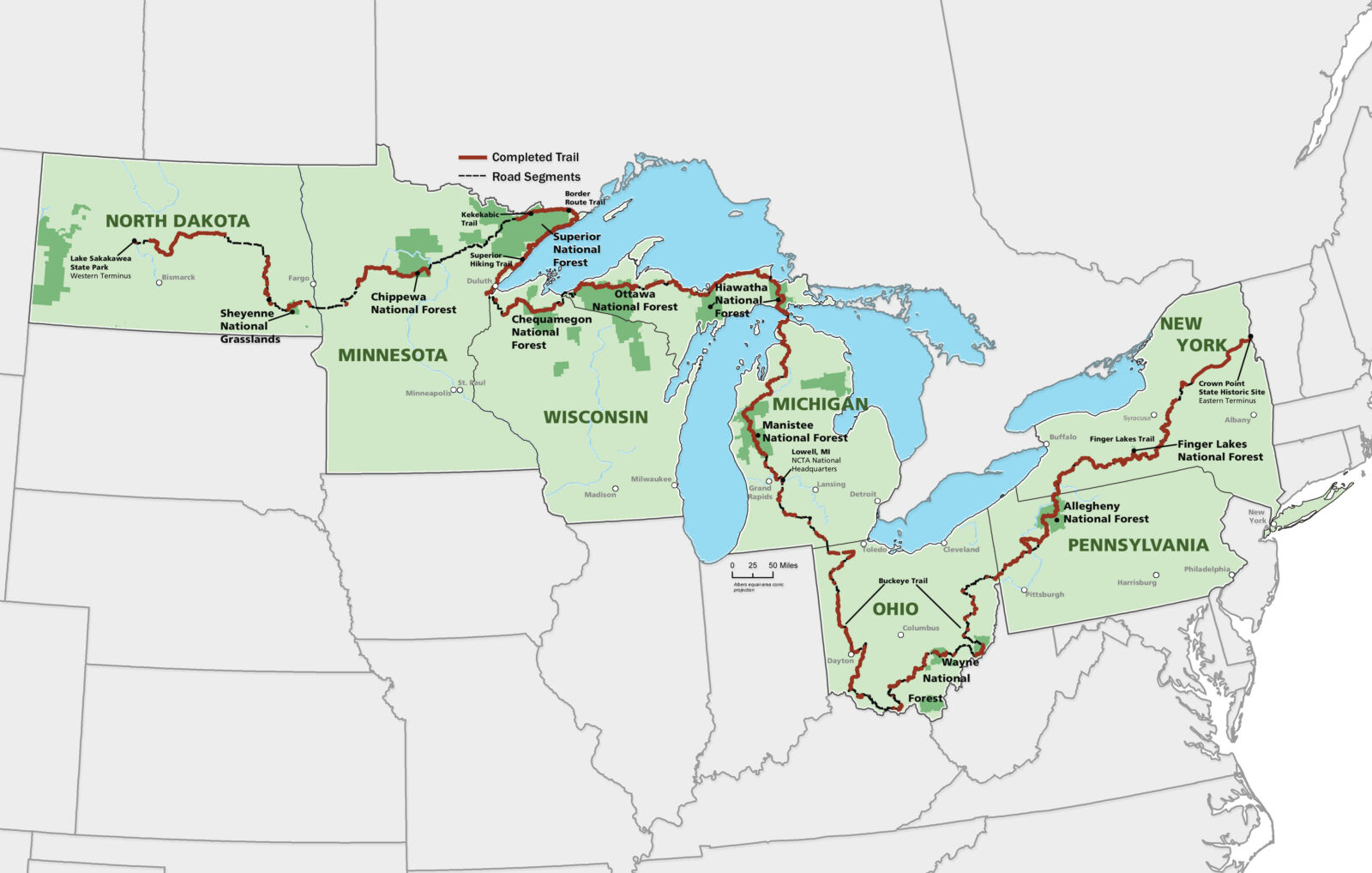
Map courtesy of the North Country Trail Association
All too often, I hear people disparage the NCT as a trail far from completion. While it’s true that there are many miles yet to build, consider this surprising fact: the NCT has more miles of off-road trail than any other National Scenic Trail. This has been accomplished in only 30 years and with no ability to acquire land until 2009. Its daunting length, twice that of the Appalachian Trail, results in the misconception that it offers little off-road treadway.
Wilderness
Some people consider anything beyond their backyard the “wilderness.” Of course, the Forest Service has a specific definition, which provides experiences more intimate and free of human intrusion. Happily, the NCT is allowed to pass through four such areas: the McCormick in Michigan, Porcupine and Rainbow Lakes in Wisconsin, and the famous Boundary Waters Canoe Area of Minnesota. As hikers traverse these special areas they may experience a unique sense of connection with a quiet past.
Much of the trail affords what might be officially called a backcountry experience—places where a hiker can disappear into the woods for two or more days and be free of many of the sounds and sights of the populated world. It is wonderfully refreshing to allow yourself to be enfolded in the forest, putting aside any awareness of the fact that a major highway may be just a mile or two away. Other portions of the trail still require support and day hiking, with few places yet to camp overnight.
State by State
Currently, the termini of the trail are Crown Point, N.Y., and Lake Sakakawea, N.D. Entering New York one first encounters the Adirondack Mountains. The Adirondack Park Agency has yet to provide the NCT with a route. The High Peaks are every hiker’s dream, but almost certainly these will not be a part of the trail. A general corridor has been established through the southern Daks, but it is still being negotiated. From the town of Rome,
NCT hikers will follow the Erie Canal into the Finger Lakes Region, and drop down to the Southern Tier following the Finger Lakes Trail system.
Pennsylvania is characterized first by the Allegheny Reservoir and Plateau, and then by the Clarion River as the trail turns westward. In Ohio, the route follows the Native American “Great Trail” and Sandy and Beaver Canal to Zoar where it joins Ohio’s Buckeye Trail, the longest loop trail in the world. Taking the southern arm, hikers descend to the Ohio River, and then wend westward nearly to Cincinnati, where they turn to the north. Following the Little Miami River and the Miami-Erie canal up the west side of Ohio, and taking a short turn east on the Wabash-Cannonball Trail, 1,800 NCT miles are traveled before entering Michigan.
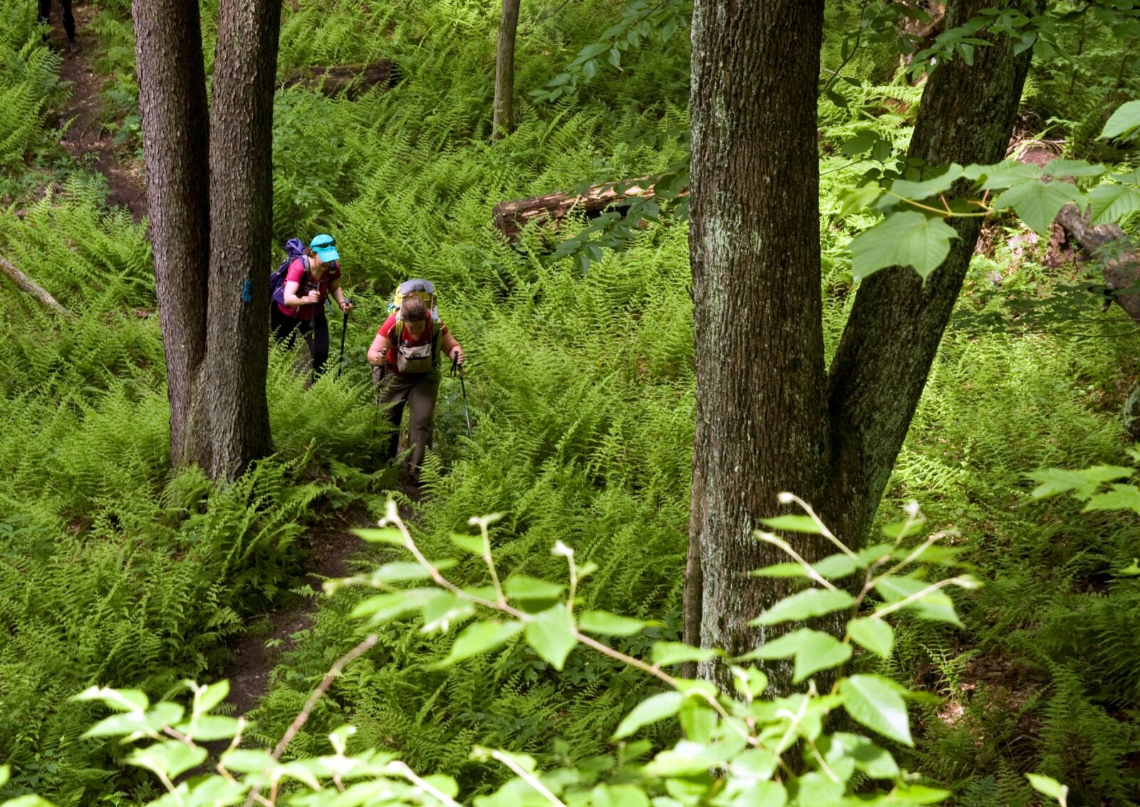
Photo by Mike Henderson
Hikers on the Allegheny National Forest.
Michigan, by itself, boasts 1,200 miles of the NCT. The Lower Peninsula offers miles of remote but relatively easy hiking, a good place for beginners to test their mettle. The Mackinac Bridge is an official part of the trail, but can only be walked on Labor Day. Thru-hikers appearing there will be carted across by truck. The Upper Peninsula is much more desolate and remote than Lower Michigan. Miles along the lonely Lake Superior Shore, including Pictured Rocks, will satisfy any wanderer. The western UP offers days of hiking with no man-made structures to intrude on a hiker’s thoughts.
Wisconsin may have few miles of the NCT but Copper Falls State Park serves up geologic wonders and with recent trail building in Douglas County, it may be the first state to have all NCT miles completed off-road.
In Minnesota, the NCT follows the Superior Hiking Trail, Border Route and Kekekabic Trail to trace the Arrowhead region, providing an overdose of scenery for those willing to take on the challenges of the terrain. Returning to the center of the state, the trail continues west across the remains of Glacial Lake Agassiz to reach Fort Abercrombie on the Red River.
Crossing the rolling prairies of North Dakota, a hiker with eastern eyes is awed by the big sky. From Fort Ransom, the trail follows the Sheyenne River for 200 miles to its headwaters and then continues beside the McClusky Canal to reach the Missouri River and Lake Sakakawea.
The Future
Already, the NCT is considered the key component of the Sea-to-Sea route, which also includes the International Appalachian Trail and the Pacific Northwest Trail. One has to wonder how official connections will be made.
Discussions are taking place to extend the trail into Vermont to join with the Appalachian Trail. Some dreamers are scouting possible connections to the west through Montana. The completion of such plans depends upon events which are not dear to the hearts of hikers, such as politics and funding. Much energy will also be required, which hikers do possess in abundance.
The North Country National Scenic Trail is coming of age, ready for discovery by many more than the handful of hikers who already love its diversity. Take its new slogan to heart and believe that “Your Adventure Starts Nearby.”
Joan H. Young is the
first woman and only the 10th person to complete the NCT on foot. She has
written a book about her experiences, “North Country Cache,” and is currently
working on the sequel to finish the journey which will be called “North Country
Quest.”
Click here for more information about the North Country Trail Association.