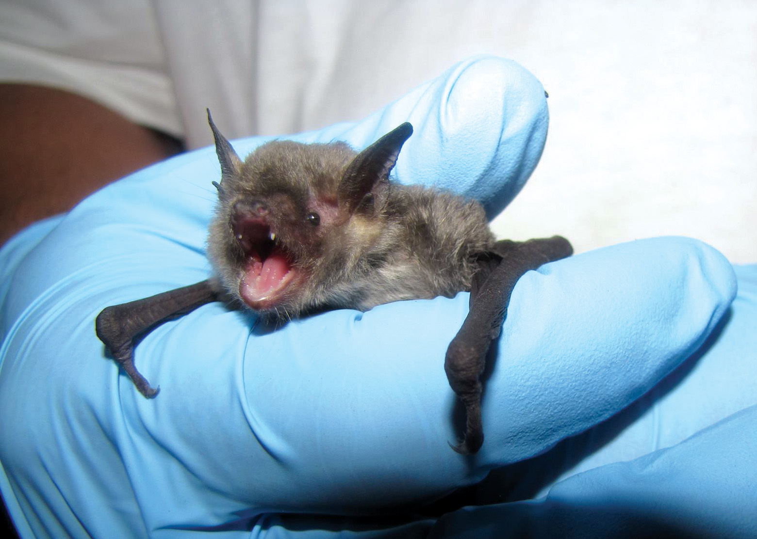
Like the proverbial needle, these bats were proving exceptionally hard to find, especially since they were nowhere near where Ford expected them: around the rocky, cliff-hanging forests near Pigeon Mountain, Georgia. But there he was, scouring 7,000 square miles of Georgia for a dark gray, fist-sized, nocturnal species.
Working at the time for the U.S. Forest Service Northern Research Station, Ford was collaborating with the Georgia Department of Natural Resources and West Virginia University to document gray bat habitat use and movements across northwest Georgia.
Gray bats typically stay relatively close to their roosting sites, usually within a 10-mile radius. So when they picked up gray bat calls more than 20 miles away from known roosting sites, Georgia wildlife researchers used Ford’s recordings and analysis to discover two previously unknown gray bat cave roosts. That revelation helped forest managers determine how to best manage the area for the endangered species.
He laughs now to think about it: the acoustical detectors he used to record the endangered gray bats’ ultrasonic calls in real time, were super cutting-edge technology.
Everyone was running around, going out in canoes with our laptops, trying not to flip into the Tennessee River, then driving furiously to the next place to sample everything in the landscape.
Ford is still chasing bats, but today instead of a handful of detectors and arduous weeks of data analysis with clunky computer tools, he uses 150 detectors and software that crunches individual species’ sonar signatures in minutes.
“I think back to my Forest Service days, with my five little detectors, and how I thought I was such a big shot. It’s astounding what we can do now.”
Ford’s application of high-tech gadgetry is not just for bats: these cutting-edge tools and innovative data analysis programs are an increasingly necessary way to quickly collect, analyze and interpret high-quality data across vast swaths of land—data that are used to inform a bewildering array of on-the-ground decisions for forest and wildlife management.
Now at Virginia Tech, Ford’s current work collecting data on the location and activities of the endangered Indiana bat and threatened northern long-eared bat is helping inform decisions about timing of timber harvests or prescribed burns. His acoustic mapping allows land managers to see or predict when bats will enter hibernation, for instance, resulting in known “safe” periods when management activities won’t affect the bats.
As Ford says, “If the Forest Service knows what the conditions are that make a good landscape, then they can plan for how to maintain them.”
Making Maps For Owls
In Oregon, Forest Service biologist Todd Wilson studies factors that impact threatened northern spotted owls, especially their prey and habitats. The owl relies on northern flying squirrels and woodrats as two of its primary food sources.
Wilson has been using lidar (laser-based radar imaging) to create images of forest plots in different
wavelengths. He and his research partners made 360-degree scans of areas with healthy flying squirrel populations, curious to learn what it was about the mid-story levels of the forest that was so important to the squirrels.
Their scans revealed a highly detailed, quantifiable view of the forest Wilson had never had access to before —a direct way of measuring the forest’s structure that could be compared to other study plots. For decades, lidar equipment was too expensive and rare for use outside of military or meteorological work, but commercialized lidar is now accessible enough to use in broader applications, including wildlife research.
When you’re dealing with wildlife, so much depends on how things are arranged in space. Lidar gave us a picture of the [forest] stand we never had before, and because we know the midlayer is so important for the squirrels, we could start to look for some defining thing that establishes high-quality forest for squirrels.
Though he is still analyzing the lidar data to determine which characteristics of each midlayer section make it so attractive to squirrels, he can already say that scans of each forest type result in distinct, distinguishable signature patterns when charted as graphed data.
“Previously we could say, here’s a young managed forest that we want to make more structurally complex, more like old growth,” Wilson said. “But we didn’t have any good metrics to say we’ve achieved what we wanted to. Now we can actually scan these forests and use these digital signatures to give us benchmarks as we go through time, as well as benchmarks to work towards.”
Information like this is already having real-world impacts for spotted owl management, such as when and where to thin in the Siuslaw National Forest along Oregon’s central coast. “If you have a young stand that’s scheduled for thinning that has a lot of squirrels, should we be thinning there if the owls might need those squirrels? They’re making decisions like that now, based on our findings on the ground.”
Who’s Who? E-DNA and Wildlife Populations
Advances in genetic and genomic data capturing are also providing an eagle-eyed look at animal populations, densities and even identities and relationships. One technique becoming increasingly valuable is analyzing e-DNA, or environmental DNA, mitochondrial genetic material that is released into the environment via feces, urine, shed hair and other sources.
In Montana’s Bitterroot National Forest, citizen scientists are working with the Forest’s biologists to use camera traps and e-DNA analysis to determine exactly how many wolverines are roaming the forest’s snow-covered peaks. Traditional camera traps can help show that there are wolverines, but it can be difficult and inaccurate to rely on photos alone to differentiate between individuals. E-DNA makes these individual distinctions extremely reliable.
To date, the team has discovered at least four individual wolverines on the forest. Previously, there were no reliable data that indicated even a single wolverine living on the forest.
Drones, Tiny GPS and More
Plenty of technologies exist today that are close, but not quite ready for wildlife primetime. Drone flights for research are still essentially banned on Forest Service lands, but once they do gain approval there, Wilson says it could be transformative. He ponders how drone-borne lidar could zip down a steep transect of old-growth forest, stitching that imagery and data together quickly in the lab.
Tracking individual animals via tiny GPS tags is another dream of the wildlife conservation community. While GPS technology works great for animals above a certain weight—larger birds and bats, for instance—it’s still not small enough to safely be used on some of nature’s smallest creatures such as hummingbirds and butterflies.
Roland Kays, an associate professor of forestry and environmental resources at North Carolina State University, has been researching animal movement and behavior with camera traps, as well as refining methods for how citizen scientists can help collect more and better wildlife data. He’s also part of Project Icarus, an initiative led by Martin Wikelsi at the Max Planck Institute for Ornithology, to shrink GPS satellite tags down to five grams, then eventually a single gram. This “shrinking” is critical if researchers want to track the ruby-throated hummingbird for example, which weighs between two and three grams.
Scientists may be prone to experimenting (and inventing) new technologies that can help them with their work, but these new sensing, mapping, identification and tracking techniques have real world applications for forest managers.
“Technology lets us learn more stuff, faster, over larger areas,” Kays says. “There are so many ways that can help us make more informed conservation decisions.”