The Appalachian Mountains are some of the oldest in the world. Geologists believe the Appalachian Mountains were as tall as the Himalayans before a billion years of weathering and erosion. This mountain range runs from Alabama to Canada, and I am proud to reside here. However, with climate change models predicting more extreme seasonal flooding and drought events, supporting watershed resiliency is crucial for anthropogenic infrastructure and endemic species ecosystems.
The U.S. Forest Service’s Southern Appalachian Subregion (SAS) is doing just that. Their focus has been communicating with local parties to distinguish needs and collaborating with partners to secure funding for watershed resiliency projects, and as an NFF Conservation Connect Fellow I was able to support these efforts. But where to start? HUC 12 watersheds are the focus. Hydrologic Unit Codes, or HUCs, are unique numeric identifiers that tell the location of the watershed; the longer the code, the more specific. Twelve condition indicators were used to classify watershed conditions, including water quality and quantity, aquatic habitat and biota, riparian/wetland vegetation, roads and trails, and fire regime. These indicators represent the underlying ecological and hydrological functions that support a heathy watershed. Each indicator was rated to determine each watershed condition classification, as seen below.
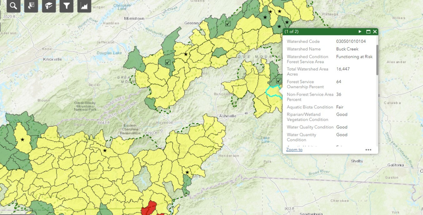
Watershed Classification (green = functioning properly, yellow = functioning at risk, red = impaired function). View Watershed Condition Framework here.
With all this information on current watershed conditions, how do we prepare for future needs? Future climate data is modeled for different scenarios based on the policies we carry out today. The USDA Forest Service Office of Sustainability and Climate developed an interactive StoryMap showing how climate change will affect streamflow. This map shows that in my region, mean flow will potentially increase by up to 10% (darker green color).
With this information we know stormwater runoff could increase, along with erosion and sedimentation potential. This means a unique strategic plan will be needed for each individual watershed depending on potential change. During my summer service, I added key geomorphologic, ecosystem, and climate data to a Watershed Restoration Action Plan (WRAP) to three watersheds in the Southeast. Specific project proposals will be written in the WRAP along with funding needs and partner roles. This is part of a bigger national push for watershed restoration by the USDA.
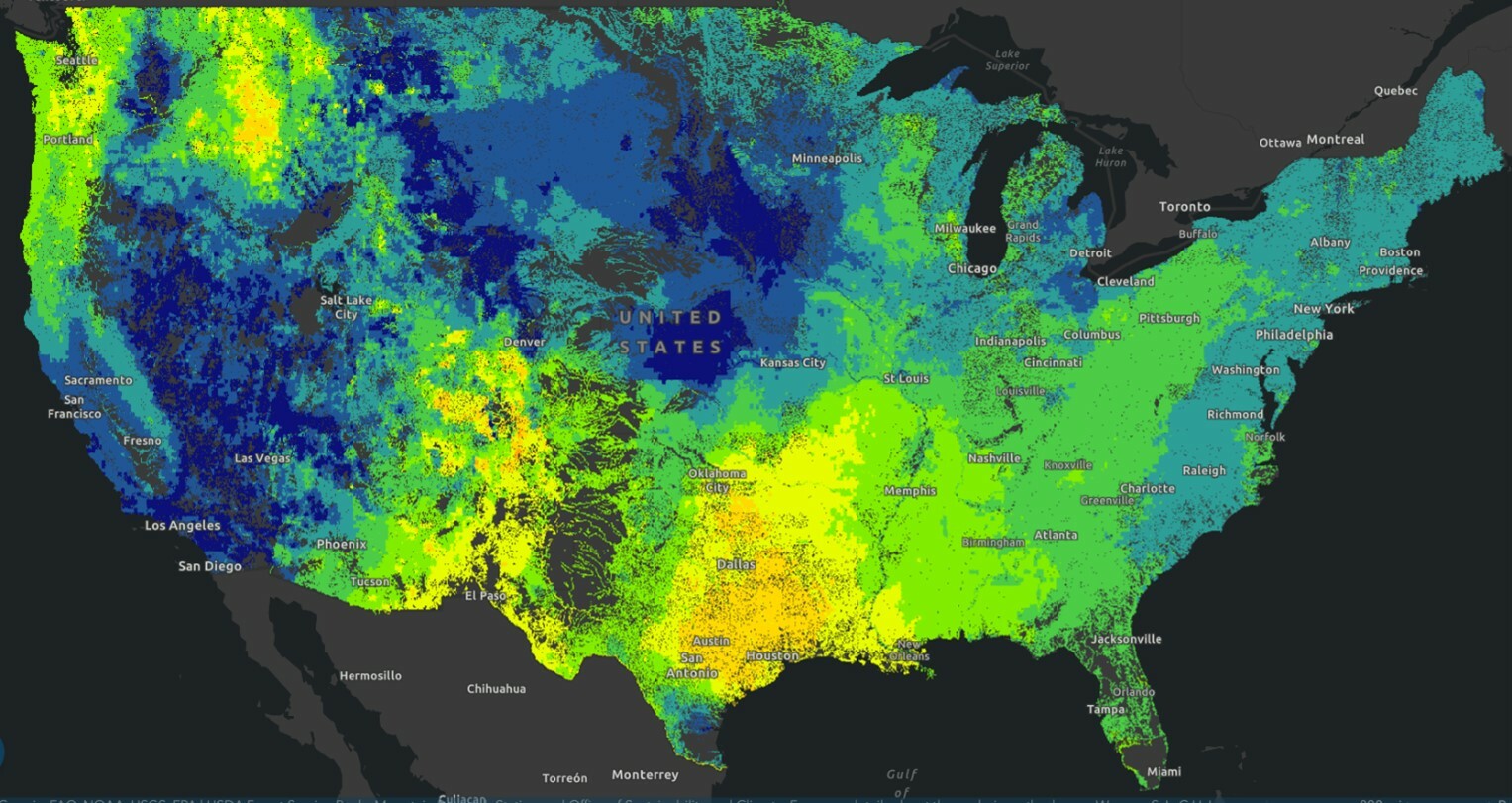
Map shows percent mean streamflow change from current to end of century (2070–2099) using RCP 8.5 scenario.
Now we know what the watershed needs, but what about the people in local communities who live here? Watersheds do not follow political lines, and some have strong economic ties to recreation and timber and provide drinking water supply. The Climate and Economic Justice Screening Tool helps to shed light on the needs of the local community. The census tracts show areas of disadvantage to help support the need for action.
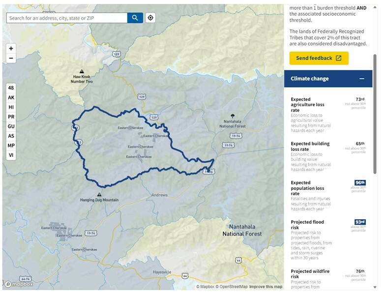
This highlighted census tract shows expected fatalities resulting from natural hazards and a high flood risk compared to other tracts.
All the tools mentioned above play a part in accomplishing quality projects by providing a solid understanding of the watershed. Now that all the accredited sources of information are collected, the beauty of collaboration blossoms. Individuals, government agencies, nonprofits, and other partners can align to reach a mutual goal. Teams are formed to make sure everyone's voice is heard, and values respected. Creativity thrives in maneuvering complex systems such as the National Environmental Policy Act (NEPA), the Forest Plan, and grant writing. Constituents volunteer to take on parts of a project so the mental load is not on any one person. It was a wonderful experience witnessing and participating in the organic nature of the alliance. People from all occupations come together because they care for the land and serve the people.
Katherine Gonzalez is a 2023 Conservation Connect Fellow. She is pursuing a graduate degree in Geographic Information Systems (GIS) at West Virginia University, allowing her to focus on environmental issues and make maps for wildfires during the summer. She is very excited to have worked on watershed issues during her fellowship and further care for the public lands that she knows and loves.
Cover photo by the U.S. Forest Service.
--------
Did you learn something new in this blog post? We hope so! The ecology that binds together everything on our National Forests is a fragile web, and we at the NFF are committed to doing all we can to ensure the healthiest forest ecology we can. To do so requires the support of caring individuals like you. Will you join us to ensure this critical work continues? Simply click here to join with thousands in this important work. Thank you!