Government Trail - White River National Forest
Located near Snowmass, Colorado this is a local favorite that takes riders up through beautiful Aspen Groves, drops them over roots and other technical features and leaves them wanting more! Government Trail provides an intermediate to expert singletrack experience from the eastern flanks of Snowmass Ski Area to the Tiehack side of Buttermilk Ski Area. The portion that is west of the Buttermilk Ski Area boundary is closed May 15 - June 20 for elk calving season.
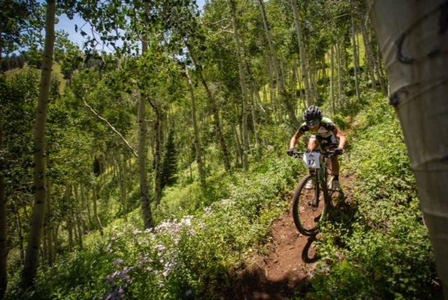
Photo by Jeremy Swanson
Click here for more information about Government Trail.
Boreas Pass - White River National Forest
Looking for something a little more mellow? Try Boreas Pass as a great place to warm up for beginners with wide track that is also open to motorized use. At just under eight miles, it doesn’t contain anything too technical and has a gentle ascent with great views of the Tenmile Range
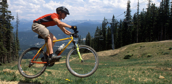
Photo courtesy of Lisa Gibson Photography and Breckenridge Mountain Resort
Click here for more information about Boreas Pass.
Mesa Top Trail #714 - Grand Mesa National Forest
Take a ride through dense forest and open grassy flats, hug narrow benches clinging to the rim and snake through shimmering Aspen glades! The spectacular Mesa Top Trail atop of the world’s largest flat-top mountain is currently a three mile non-motorized single track that will soon connect with the popular Flowing Park Trail. Still in progress, the connectors will provide several looped trail options ranging from 6 to 28 miles.
The existing three mile section open for bike riders and hikers can be traveled as easy out-and-back with no long climbs and very few technically challenging features.
Photo by Marianne Fifield
Photo by Sara Mah Withers
Click here for more information about the Mesa Top Trail #714
Indian Point #715 and Flowing Park #715A Trail Loop - Grand Mesa National Forest
At the rim of the Grand Mesa on Indian Point, you can experience one of the Grand Mesa’s most spectacular views. On a clear day, Kannah Creek Basin, the La Sal Mountains, the Uncompahgre Plateau, and the Grand Valley can all be seen. A trail for intermediates and experts, the Indian Point trail meanders through oak brush/sage, snowberry/serviceberry and aspen/fir forests on the way to Indian Point.
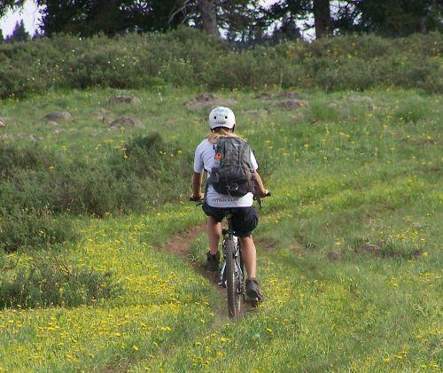
Photo by the U.S. Forest Service
Click here for more information about Indian Point #715 Trail.
Galloping Goose Trail #499 - Uncompahgre National Forest
Explore the area’s rich railroad and mining history via mountain bike along the Galloping Goose Trail. Centered around Colorado’s history, this is a classic bike ride is an 8.4 mile adventure through time, following the historic Rio Grande Southern (RGS) Railway that was built in 1891 and served mining communities in the region. Stop and browse the restored train trestle, water tank, coal chute facility, railroad ties and other historic features. Ride over two trail bridges, through a highway underpass, and along segments of the historic RGS railway.
The trail begins along Highway 145 on Lizard Head Pass and ends on State Highway 145 just 4 miles west of Telluride. The route is diverse, traveling along forest roads, single track trail, and portions of the historic railroad grade. The trail is often done in sections by starting at Lizard Head Pass then biking down the trail to ultimately end at a small parking area on County Road 63J (near the church camp).
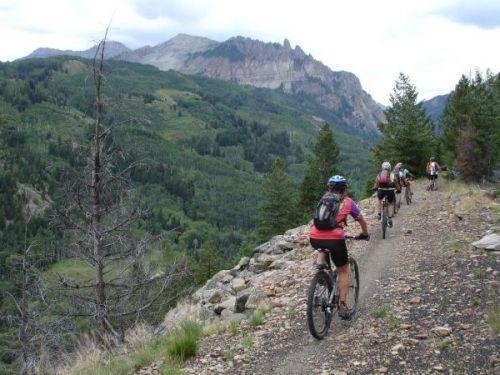
Photo by the U.S. Forest Service
Click here for more information about the Galloping Goose Trail #499
The Hewlett Gulch Trail #954 - Arapaho-Roosevelt National Forest
Located in the Poudre Canyon in Larimer County on the Roosevelt National Forest and adopted New Belgium Brewery with support from the Diamond Peak Bike Patrol, this trail is very popular with hikers and bikers alike.
The trail travels north from the Poudre Canyon following an old road along Gordon Creek. Along the way it passes foundations of old homesteads from the early 1900s. At the two mile mark, the trail forks. The main trail continues north and winds through a narrow canyon with many stream crossings before heading uphill out of the drainage into a meadow. The left side of the fork is a loop, which eventually reconnects to the main trail. Depending on your chosen route, the trail is four to six miles round trip.
While you travel this trail, you will see the remnants of a busy fire year in 2012. Both the Hewlett Fire and the High Park Fire burned in this area – a stark reminder to always be safe with fire. This trail was also impacted by the floods of September 2013 that hit northern Colorado.
Photo by the U.S. Forest Service
New Belgium Brewery has adopted this trail with support from the Diamond Peak Bike Patrol to help with the maintenance and patrolling of this popular trail.
Click here for more information about the Hewlett Gulch Trail #954.
WTB Trail - Arapaho-Roosevelt National Forest
The 1.8 mile WTB trail has something for everyone—essentially three different trails depending on which portion of the trail you ride. The western portion of the trail that connects to FS 892 is steep, rough, rugged and for the rider looking for a technically and physically challenging ride. The eastern portion of the trail, beginning from D4, connects into Akima’s Way, which can take you to town or to multiple other trail options. The eastern portion of the trail is flowy, featuring banked turns and multiple options to ride on natural and constructed features (wooden ladders, skinnies, boulder rides). This portion of the trail also has ride-a-rounds that allow more novice riders or groups with riders of different abilities to bypass these features.
WTB is in the heart of the riding area just outside of the town of Winter Park and is perfect for a wide range of riders.
Photo by U.S. Forest Service
Click here for more information about the WTB Trail.
Forest Trail 787 - Rio Grande National Forest
Ride on top of a mesa on the Rio Grande National Forest! This trail is about five miles and partly above tree line providing fantastic views of the Weminuche and La Garita Wilderness Areas. In this remote part of the state, you may just have the trail to yourself!
The best access is at the trailhead on the east side of Spring Creek Pass on the Gunnison National Forest. The trail climbs up to Snow Mesa and the Rio Grande National Forest and then it is clear riding on top of the mesa. 787 and 813 trails are together for about 5 miles, then they separate. Make sure to take the 787 trail and it will drop you into the headwaters of Miners and Oso Creeks where it connects with a 4x4 road that will connect to a forest road that will lead to Creede, CO. In theory, a biker could ride right into Creede!

Photo by U.S. Forest Service
For more information about Forest Trail 787, contact the Rio Grande National Forest.