NFF believes in the value of matching the cutting-edge knowledge acquired at the graduate level of universities with practical, hands-on experience. Over the last few years, though programs like the Conservation Connect Fellowship, we have increased our focus on providing and amplifying this type of knowledge exchange.
In this vein, we are delighted to highlight a partnership between the Facility for Advanced Spatial Technology, University of Colorado - Denver’s Geospatial learning and teaching hub and the Colorado Mountain Bike Association (COMBA). Students from the FAST Lab are coordinating with COMBA, the U.S. Forest Service, and other agencies to create useful tools and relevant analysis that may ultimately help land managers manage recreational resources across Colorado.
Jenn Ambrose, FAST Lab, shared the following:
Living in the digital age where remote communication and connection is common-place, connecting community partners, ideas, and resources is becoming easier than ever. Brian Fox of Colorado Mountain Bike Association (COMBA), saw such a potential for inter-agency cooperation. Spearheading a relationship between geospatial students from the University of Colorado at Denver (UCD) and Colorado land managing agencies such as Forest Service and Colorado Parks and Wildlife, Brian has imagined a win-win for both parties: students get access to real-world application for the concepts and skills they are learning in classes while agencies get academic analysis for projects that have been placed in the “when there’s time” category.
Geospatial analysis is the science of when the ‘where’ something happens matters. While it is chalk-full of intimidating terms – raster resolution, vector geodatabases, Boolean overlay – it is basically a way of visualizing data that have a spatial component (a ‘where’ to it) and analyzing overlapping ‘where’ components that come together to form a unique insight that may not have been obvious before. Geospatial analysis can be applied to a vast array of disciplines and, with the development of new data sources – crowdsourcing, app analysis, open data repositories – the possibilities are expanding every day.
This past semester, a volunteer group of students working within the FAST Lab, UCD’s spatial learning and teaching lab that supports geospatial-specific academic programs and initiatives, used their mapping skills to address concepts of interest to land managers. From analyzing spatial and temporal user data gathered by a recreational exercise app, to using specialized computations to identify specific parts of the Colorado Trail of concern, students got to think critically about how the spatial techniques and software capabilities they have learned might shed light onto topics of interest.
Brian Fox, Colorado Mountain Bike Association, added sentiments as well:
Outdoor recreation is such a critical part of Colorado, including its economy and the recreational infrastructure that must be managed by government entities throughout the state. Whether trails, trailheads, parking lots, picnic areas, and a myriad of bridges and other structures, these features enable the public to safely enjoy their lands.
Resources to effectively manage critical recreational infrastructure are always limited. Not only are land management budgets pretty tight, but there’s only so many volunteers, too. I have seen the potential for geospatial analysis to help inform organizational decision making, focusing limited resources on critical issues and important opportunities. While my experience was focused more on scientific or intelligence related issues, I saw the potential for Geographic Information Systems to help identify opportunities for land managers and the volunteer organizations that partner with them to improve how data enabled their decision making processes.
So, in early 2019, as a member of the Colorado Mountain Bike Association (COMBA) I worked with the University of Colorado - Denver to conduct geospatial analysis of trails along the Front Range. The students' initial efforts were shared with land managers that August, highlighting critical issues like erosion along a trail based on its slope and precipitation, or trails likely to be impacted by trees killed by bugs. This initial effort caught the attention of Forest Service, Rocky Mountain Region, which was included in identifying important analytical topics for students to analyze in early 2020. These students from the Facility for Advanced Spatial Studies (FAST) Lab studied a range of topics, and then shared their analysis USFS staff earlier this spring.
We hope to continue this kind of partnership between COMBA, the University of Colorado - Denver, and the Forest Service, bringing talented volunteers to bear, helping all that are involved in managing public lands to better understand where to focus our limited resources for the greatest positive effect.
In the following articles, you’ll see specific examples from University of Colorado-Denver students, demonstrating how geospatial analysis can help answer difficult questions for land managers and their partners.
Click below to check out a snapshot of the graduate student projects, as depicted in blogs, maps and images:
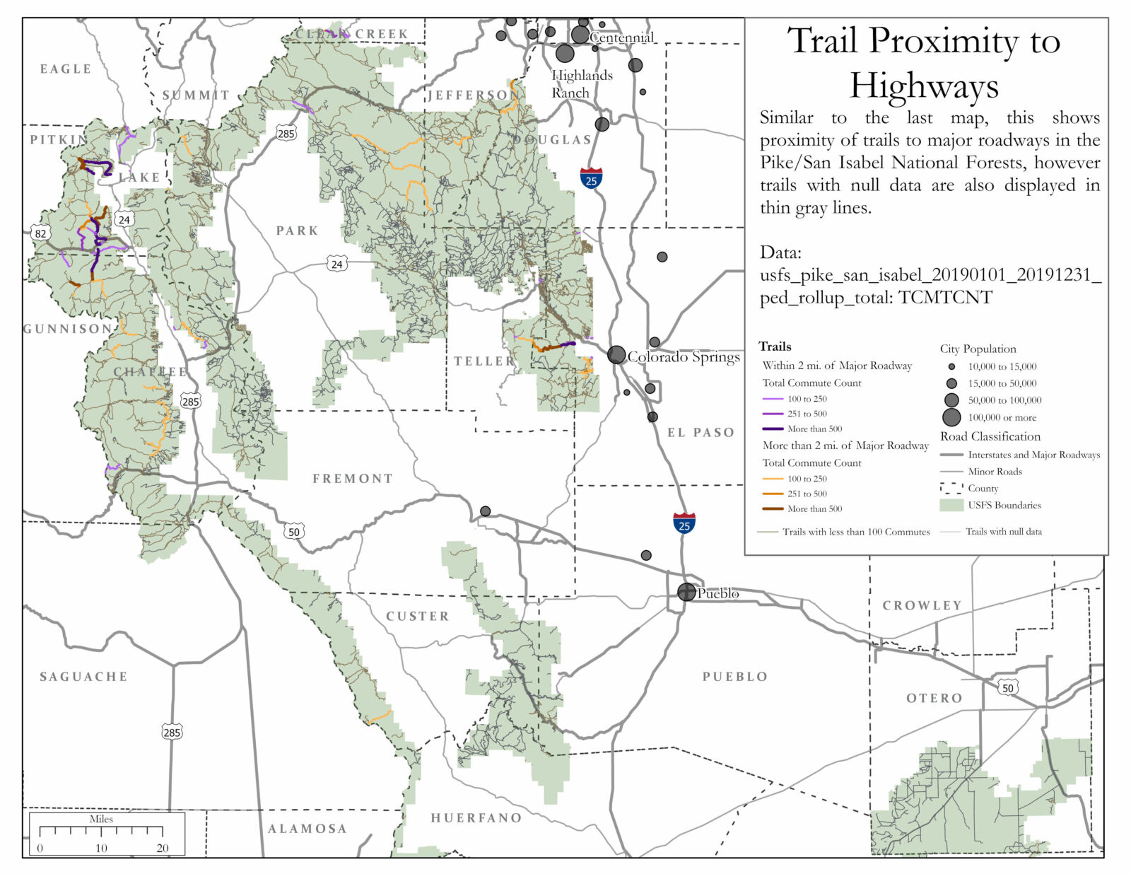
- Trails with Proximity to Highways, Elizabeth DeRycke
- Apex Park: Pedaling towards a Greener Future, Alena Gagnon
- Colorado Trail: Preventing Erosion, Preserving Water Quality and Minimizing Wildlife Impact, Alena Gagnon