After graduating college in 2005, I wanted one final summer of adventure before entering the workforce. I hoped to spend the majority of my time outside, and so I started researching a long-distance hike. I, like most people, considered only the shortlist of usual suspects: the Appalachian Trail (AT), the Continental Divide Trail (CDT) and the Pacific Crest Trail (PCT). I chose the PCT, rounded up two childhood friends and set out from the Mexican border.
After walking through the wilderness of California, Oregon and Washington, we crossed the Canadian border. It took us five month and two days, and afterwards, I felt lucky to live in a country where such a trail existed. It turns out that if you’re like me, a person who counts their blessings in long distance trails, our fortunes are improving.
In the decade since my thruhike, Congress has designated three new long trails to bring the National Scenic Trail System’s total to 11 trails. Work crews have added hundreds of miles to existing ones, and conservation groups have proposed a handful of new routes.Amazingly, each of these trails was created through the dedication of an individual or a small group of people, a testament to how a committed individual or group can impact the nation.
Arizona Trail
Designated in 2009
The Arizona Trail begins in the Huachuca Mountains on the Mexican border and then bisects the state lengthwise for 807 miles until reaching the Vermillion Cliffs on the Utah border. The route traverses arid mountains, deserts, scablands and the Grand Canyon, before entering the deep pine forests of the Mogollon Rim. Much of the trail receives less than 11 inches of rain a year, making for thirsty traveling because water sources are few and unreliable.
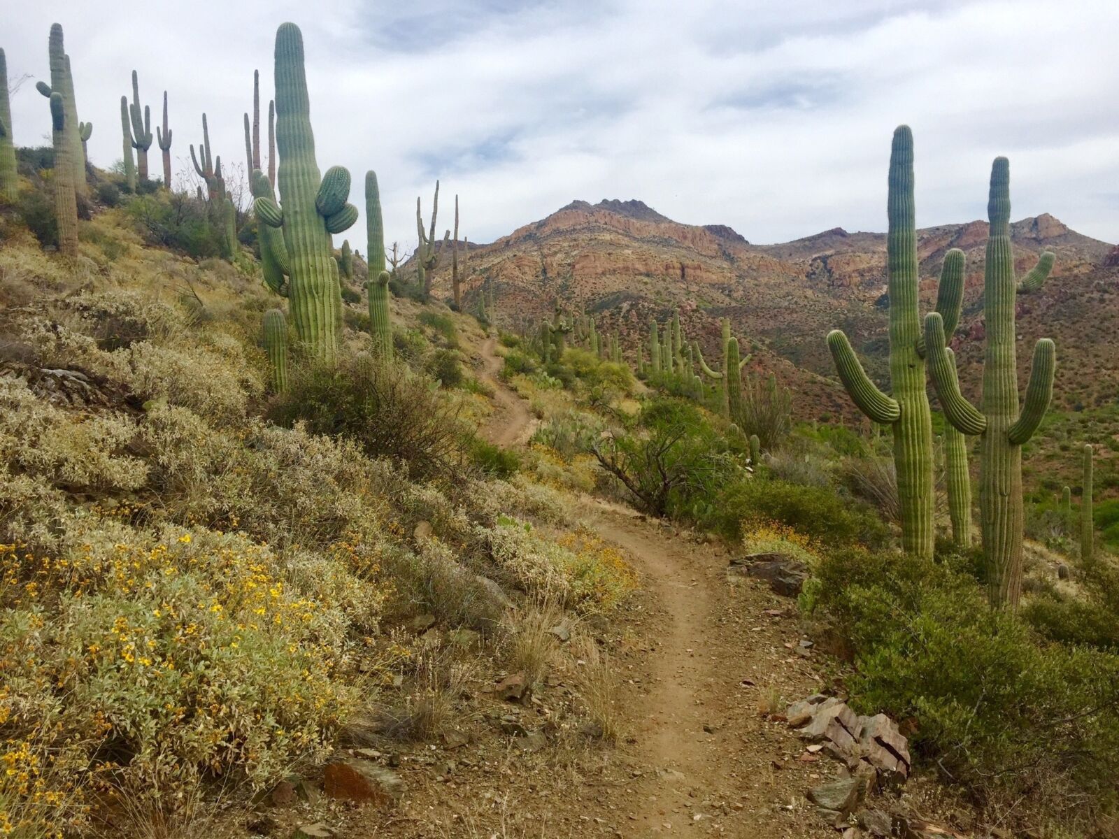
Photo by Shannon Marshall, courtesy of the Arizona Trail Association
While long-distance hiking is not for the inexperienced (Cheryl Strayed and Bill Bryson excepted), elementary school teacher Dale Shewalter first envisioned the trail in 1984 as a multi-use resource for all citizens no matter if they’re hiking, biking or horseback riding.
Now, more than 30 years later, Shewalter’s dream has become a reality. The Arizona Trail connects small towns and growing cities to the Coronado, Tonto, Coconino and Kaibab National Forests. It traverses state, federal and tribally-owned lands. In 2009, Congress officially designated the Arizona Trail as a National Scenic Trail, and it is quickly becoming one of the premier long-distance trails in the country.
Pacific Northwest Trail
Designated in 2009
The Pacific Northwest Trail (PNT) begins in Glacier National Park and travels 1,200 miles through
Montana, Idaho and Washington before reaching its western terminus at the Pacific Ocean. Much of the route passes through mouth-gaping terrain. It includes forays into Glacier, North Cascades and Olympic National Parks and crosses seven National Forests.
Whether park or forest, it’s all wild, rugged country that provides some of the few remaining strongholds for grizzly bears in the Lower 48.
The trail connects diverse towns such as Montana’s pioneer-vibed hamlet of Yaak to Puget Sound’s artistic, seafaring town of Port Townsend and dozens of similar towns in between. This diversity of wild landscapes and unique heritage is exactly why Ron Strickland spearheaded the movement to protect the route beginning in 1970. Nearly 40 years’ worth of advocating for the PNT culminated in Congress’ officially designating it a National Scenic Trail in 2009.

Photo by Andy Porter, courtesy of the Pacific Northwest Trail Association
Only ten to fifteen thru-hikers complete the trail each year (compared to the hundreds who complete the Appalachian Trail), and it is quickly earning a reputation as one of the most challenging thru-hikes in the National Scenic Trail System.
New England National Scenic Trail
Designated in 2009
The New England Trail (NET) travels though the most densely populated areas of any of the other trails in the National Scenic Trail System. Instead of traversing vast wilderness, the NET follows forested ridges overlooking farms and connecting quaint New England towns. The 215-mile trail begins on Long Island Sound, and then marches up the Connecticut River Valley into the forested glades of Massachusetts, before finally reaching its terminus at the summit of Mount Tom on the New Hampshire border.

Along the way the trail connects more than 41 different communities. Much of the trail existed as three separate trails before individuals, groups and local governments united to make the NET a reality. Their work helped establish the NET as a National Scenic Trail in 2009 as part of an omnibus and bill signed by President Obama. The trail is 100 percent completed, but there are plans to extend it farther into New Hampshire.
Cohos Trail
Completed in 2011
The 162-mile Cohos Trail in Northern New Hampshire is as rugged as New England gets. It begins in the 800,000-acre White Mountain National Forest, home of the mighty, wind-scoured summit of Mt. Washington. It treks through birch bogs, up lonely granite peaks and continues north through the length of Coos County.
After a ridgeline ramble across the Presidential Range, the Cohos seeks out more isolated, remote landscapes.
Volunteer trail crews finished construction in 2011, 33 years after a local New Hampshire newspaper reporter, Kim Neilson, first dreamed of the trail. Now that Neilson has succeeded in creating his dream, he has no plans to stop. His goal is to continue the Cohos Trail another 20 miles along the Canadian border until it connects with the Frontier Trail in Quebec. Once that is accomplished, the Cohos Trail will become a part of the North Woods Loop, which will ultimately connect to the Appalachian Trail in Stratton, Maine. The Cohos will form the New Hampshire section of the 365-mile North Woods Loop that, aside from the Appalachian Trail, will be the longest and wildest trail in the East.
The Oregon Desert Trail
Uncompleted
The Oregon Desert Trail (ODT) is an 800-mile dream in-progress. The route connects a smorgasbord of public lands between the outdoorsy mecca of Bend, Oregon and the remote Owyhee Canyonlands on the Idaho border. The Oregon Natural Desert Association spearheaded the effort to build a trail in 2011 by piecing together a route on existing jeep tracks, open paths across Wilderness Study Areas and on existing trails through places like the Fremont National Forest. The result is an exciting, brand new trail that traverses the oft-forgotten Oregon desert.
Photo by Jeremy Fox, courtesy of the Oregon Natural Desert Association
Before you set off on an extended portion of the ODT, you should know that the route requires significant planning. There is very little water along the trail, and even though a route is mapped out, trail signs or any on-the-ground assistance is non-existent at this point. Even with these barriers, a few brave souls are already hiking the full trail and gathering valuable information—the most famous of whom is Triple Crown finisher (a thru-hiker who has completed the PCT, CDT and AT) Sage Clegg. A wildlife biologist and resident of Bend, Oregon, Clegg completed the entire ODT in July, 2013 to help the Oregon Natural Desert Association raise awareness for their fledgling idea. Now, this trail that connects public lands in the dry side of Oregon is becoming the newest of the new long-distance hiking trails criss-crossing the nation.